
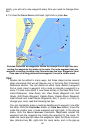
0
Owner's of the Brunton GPS Receiver MapCreate6 gave it a score of 0 out of 5. Here's how the scores stacked up:
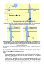
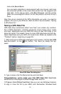
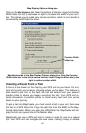

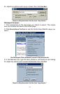


Map Display Options dialog box.
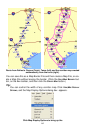
Click on the MAP BORDERS tab. Near the bottom of the box, drag the Corridor
Width slider bar left to decrease or right to increase the width of your corri-
dor. This allows you to make very narrow corridors, which in turn results in
conveniently small Map File sizes.
Corridor Width
slider bar
Map Borders tab in the Map Display Options dialog box. Drag the Corridor
Width slider bar to the left to narrow corridor width. Drag the slider bar to the
right to widen corridor width.
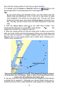
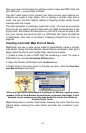
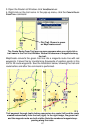
Creating a Route From a Trail
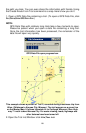
A trail is a line drawn on the map by your GPS unit as you travel. It's a re-
cord of the path you've taken, showing where you've been. This feature is
also called a plot trail. In the field, the trail will extend from your present
position back to where you began recording the trail. Your GPS unit re-
cords thousands of position points to show every twist and turn you've
taken on your journey.
To get a trail into MapCreate, you must record a trail in your unit, then save
the trail in a GPS Data File. Copy the data file from the MMC to the Map-
Create data folder. When you open the GPS Data File, MapCreate will dis-
play the trail as a green line on the Master Map.
MapCreate can use a GPS plot trail to create a route for use on a repeat
trip. Your GPS unit can navigate the new route, making it easy to retrace
65


Find Your Products By Category
Please Login
